AI Agents for Renewable Energy Developers

Unlock top renewable energy developments faster with advanced geospatial AI

A greyscale logo that says Santander UniversitiesText saying "Durham University" with their shield logoInnovateUK logoText reading "Stephen Lloyd Awards" Praeseed logo with text "powered by Praetura"A greyscale logo that says Santander UniversitiesText saying "Durham University" with their shield logoInnovateUK logoText reading "Stephen Lloyd Awards" Praeseed logo with text "powered by Praetura"A greyscale logo that says Santander UniversitiesText saying "Durham University" with their shield logoInnovateUK logoText reading "Stephen Lloyd Awards" Praeseed logo with text "powered by Praetura"A greyscale logo that says Santander UniversitiesText saying "Durham University" with their shield logoInnovateUK logoText reading "Stephen Lloyd Awards" Praeseed logo with text "powered by Praetura"A greyscale logo that says Santander UniversitiesText saying "Durham University" with their shield logoInnovateUK logoText reading "Stephen Lloyd Awards" Praeseed logo with text "powered by Praetura"A greyscale logo that says Santander UniversitiesText saying "Durham University" with their shield logoInnovateUK logoText reading "Stephen Lloyd Awards" Praeseed logo with text "powered by Praetura"A greyscale logo that says Santander UniversitiesText saying "Durham University" with their shield logoInnovateUK logoText reading "Stephen Lloyd Awards" Praeseed logo with text "powered by Praetura"A greyscale logo that says Santander UniversitiesText saying "Durham University" with their shield logoInnovateUK logoText reading "Stephen Lloyd Awards" Praeseed logo with text "powered by Praetura"

Geospatial Intelligence

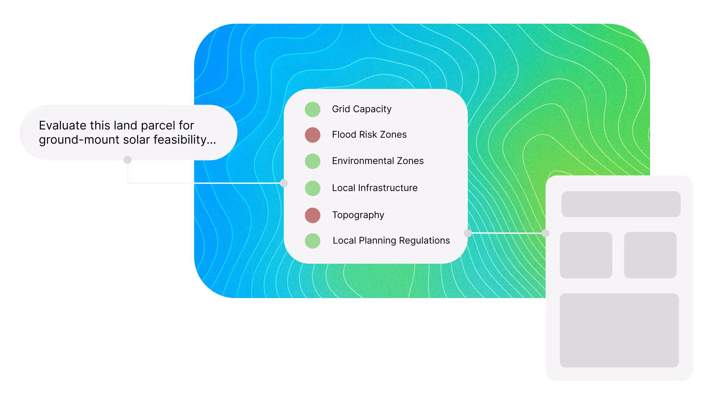
No Code. No GIS. Just Answers.

Run full site selection and feasibility workflows with a single prompt.

Illustration of Feasibly datasets and the step-by-step workflow for users

Critical Datasets

Data That Wins Projects

Uncover deep patterns across hundreds of critical datasets: feasibly handles the complexity - so you can move faster.

Green line drawing of a pylon with lightning symbol

DNO Infrastructure

Detailed coverage of substations and live DNO export/import capacity, including constraint zones and queue data

Green line drawing landscape of mountains and forests

Topography

High-resolution slope, elevation, and aspect mapping for precise terrain modelling

Green line drawing of solar panels

Solar Resource

Solar irradiance data and location-specific generation estimates for yield modelling

Green line drawing of plant growing in a field

Agricultural Land Classification

Mapped agricultural land grades (ALC 1 - 5) and nationally protected land exclusions

Green line drawing of local authority boundaries

Administrative Boundaries

Administrative boundaries including LPAs, parishes, and neighbourhood plan areas

Green line drawing of residential buildings

Neighbouring Projects

Geolocated records of operational, and pending developments, with status and technology type

Green line drawing of house being flooded

Flood Zones

National-scale surface water, river, tidal, and reservoir flood zone data, including Flood Zones

Green line drawing of geographical radar

Protected Areas & Exclusion Zones

SSSIs, AONBs, Green Belt, and other statutory designations

Green line drawing of a pylon with lightning symbol

DNO Infrastructure

Up-to-date capacity and proximity data.

Green line drawing landscape of mountains and forests

Topography

Elevation, slope, aspect, and hillshade data at 1m resolution.

Green line drawing of solar panels

Solar Resource

Assess the total radiation available at the site.

Green line drawing of plant growing in a field

Agricultural Land Classification

Identification and mapping of agricultural land grades.

Green line drawing of house being flooded

Flood Zones

High-level insight into flood risk and drainage issues.

Green line drawing of geographical radar

Protected Areas & Exclusion Zones

Extensive assessment of environmentally and historically sensitive areas.

Green line drawing of local authority boundaries

Administrative Boundaries

Locate the relevant Local Planning Authority, Parish Council, and more.

Green line drawing of residential buildings

Neighbouring Projects

Insights into solar-friendly communities and shared infra opportunities.

Get to the front of the queue

Faster

Increased Efficiency

Automate Critical Tasks

Move faster with automated workflows purpose-built for renewable development.

Feasibility Study

Our AI evaluates land parcels in seconds, assessing suitability across environmental, technical, and regulatory factors

Grid Connection

Track real-time DNO data, highlight viable substations, and align with OFGEM’s Connections Action Plan - so you can focus on projects that can actually connect

Planning Permission

Model planning feasibility so you know where communities and councils are more likely to say yes

Try the Future of Renewable Energy

Book a Demo